


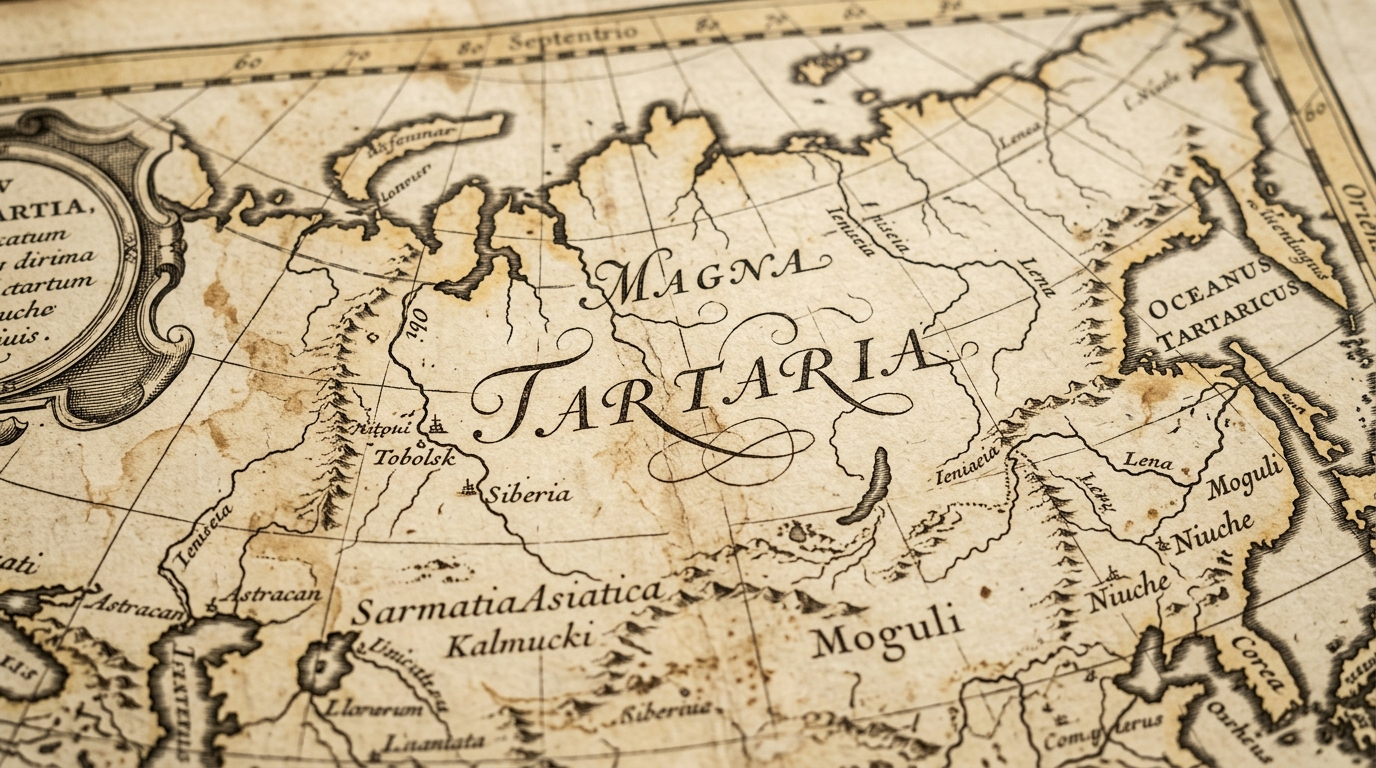
The modern “Tartaria” narrative posits a radical revisionist logic: that a global, highly advanced civilization was systematically erased from history around the year 1800. Proponents of this “Old World” theory argue that surviving architecture was “found” and repurposed by an inferior successor society, while the true history of a unified empire was suppressed. However, an investigative analysis of the source context—specifically the academic journal Tartaria Magna—reveals that “Grand Tartarie” was never a political reality, but a European cartographic label for the vast, unexplored, and misunderstood territories of the Eurasian heartland.
The Asylum Narrative: Institutionalizing the “Old World” Witnesses
A core pillar of the conspiracy theory involves the mid-19th-century proliferation of massive psychiatric institutions. The narrative posits that these structures were not constructed by the societies of the era, but were pre-existing “Old World” buildings repurposed to silence those who remembered the previous timeline.
The theory highlights specific institutions as evidence of this “re-education” effort:
- State Asylum for the Insane at Morristown (built 1876): A massive New Jersey structure allegedly completed in just five years. Proponents view its 2015 demolition for a parking lot as a deliberate destruction of historical evidence.
- Western State Hospital (West Virginia): Initiated in 1858. The narrative highlights the official claim that prisoners—untrained in specialized masonry—were responsible for its sophisticated construction.
- Northern Illinois Hospital and Asylum (Elgin): Opened in 1872, two years prior to its documented 1874 completion. Theorists argue the rush was necessitated by an urgent need to remove “Old World” witnesses from the streets.
The narrative frames these as “torture houses,” using the 19th-century admission records for non-medical issues like “laziness,” “egotism,” “asthma,” and “greediness” as proof of social control. This lore is anchored by the claim that lobotomies and electric shock therapy were specifically employed to make patients “forget the seventh tower.” Rhetorical anchors like the “666-acre” grounds of the Western State Hospital are used by proponents to imply occult origins, which they contrast with the “aura” perceived by those using “additional senses” to view these buildings.
Architectural Anachronisms: The Deconstruction of the 19th-Century Architect
The investigative historiography of this movement focuses on “impossible” architectural feats. Theorists challenge the validity of historical architects like Samuel Sloan and Richard Snowden Andrews, suggesting their resumes are fabrications designed to cover the discovery of ancient structures.
- Samuel Sloan: Theorists note that Sloan (born 1815) is credited with the Eastern State Penitentiary, which began construction in 1829. The narrative argues it is impossible for a 14-year-old to design such a “massive castle/fortress.”
- Richard Snowden Andrews: Born in 1830, Andrews was commissioned for the Western State Hospital in 1858. The theory questions how a man with only months of architectural experience could suddenly master “Greco-Roman style” blueprints for a massive facility.
Theorists further link these buildings to a global grid of “Star Forts,” complex geometric structures they claim are remnants of a unified ancient world. A representative survey of these global structures includes:
- Fort Adams: Newport, Rhode Island, USA
- Citadel of Alessandria: Alessandria, Italy
- Peter and Paul Fortress: St. Petersburg, Russia
- Fort Belgica: Banda Neira, Indonesia
- Kangla Fort: Imphal, India
- Galle Fort: Galle, Sri Lanka
- Fortress Bourtange: Bourtange, Netherlands
- Fort Jesus: Mombasa, Kenya
- Fort Goryokaku: Hakodate, Japan
- Aguada Fort: Goa, India
- Ciudadela de Jaca: Jaca, Spain
- Naarden: Naarden-Vesting, Netherlands
The Cartographic Vacuum: “Tartaria Magna” as Scientific Ignorance
The academic reality of Tartaria Magna stands in stark opposition to the “global empire” myth. Historiographical records indicate that the term was a collective European concept for territories that remained a mystery to the West. Rather than a unified state, “Tartaria” was a label used to fill the vacuum of cartographic ignorance.
The term evolved as European science progressed:
- Renaissance: A general label for unexplored territories from the Volga to the Pacific.
- 16th Century (Ortelius Map): Defined “Great Tartaria” as stretching from the Caspian to the “Oceanus Scythicus.”
- Later Periods: Expanded to include the Moscow Kingdom, Tibet, and Manchuria as explorers gained piecemeal knowledge of the Eurasian heartland.
Ultimately, Tartaria was never a political entity but an “investigative field” into the unknown, similar to the 1771 Encyclopædia Britannica definition of a vast region that was simply “uncomprehended.”
Post-Imperial Reconfiguration: The Baikal Region Case Study (1917–1923)
The collapse of the Qing and Russian empires provides a documented example of how political space is actually constructed in the absence of a central state. The following projects in the Baikal region demonstrate the competing ethnic, religious, and political interests that defined real borders.
| Project Type | Key Details/Aims |
| Buryat Ethnic Autonomy (1917) | Established aimaks (administrative units) to protect Buryat interests; lacked Provisional Government recognition. |
| Mongolian Federated State (1919) | Aimed to unite Buryatia, Transbaikalia, and Mongolia into a single state with a capital at Hailar. |
| The Daurian Government (1919) | The administrative center for the Mongolian Federated State, located at the Dauria station. |
| Theocratic State of Kudun Valley | Founded by Lubsan Samdan Tsydenov based on non-violence and military refusal. |
| Pan-Asian Kingdom | Proposed by Ungern-Sternberg as a “Middle Mongolian Kingdom” to unite Pacific to Caspian nations. |
| Soviet Project (BMAO/BMASSR) | Established in 1923; successfully unified the region by absorbing ethnic and economic principles from failed predecessors. |
Engineering vs. Myth: Infrastructure as the Tool of Control
Historical mapping and Geographic Information System (GIS) analysis dismantle the notion of “found” technology. In the Baikal region, Russian Imperial influence was not a magical “aura” but a result of hard-fought infrastructure. The Trans-Siberian Railway and the Circumbaikal Railway were strategic tools of political and economic control. The Circumbaikal Railway, specifically, was the only fast communication link around the lake; its extreme vulnerability to sabotage proves that control was achieved through difficult engineering and physical maintenance, not an inherited “global grid.”
Furthermore, while the “Old World” theory suggests grand buildings were found fully intact, actual archaeological expeditions using GIS have mapped 89 ancient nomadic city ruins (Xiongnu, Uighur, and Mongol periods). The fact that these are documented as ruins—not intact, repurposed hospitals—directly contradicts the narrative of a pre-built world that was simply taken over in 1800.
Conclusion: Research Field or Suppressed Truth?
The tension surrounding “Tartaria” persists because it occupies the gap between the perceived “aura” of ancient-looking masonry and the documented history of transcultural spaces. While conspiracy proponents view 19th-century asylums and star forts as evidence of a stolen past, the evidence points to a reality of difficult imperial expansion, cartographic ignorance, and the reconfiguration of borders following the collapse of empires. Ultimately, “Tartaria” is a legitimate term for a research field exploring the once-unknown corners of Eurasia, rather than a label for a suppressed global empire.




Leave a Reply